New Zealand Week 1 - COMPLETE
So here it is, the trip I've been dreaming of for upwards of 2 years - a long trip to New Zealand. We have a total of 6 weeks there - we'll return after Thanksgiving weekend. For those of you wondering, yes, I had 6 weeks vacation saved up. The trick was getting my employer to agree to let me take it all at once!
Anyway, we flew to into Auckland via San Francisco. Just prior to customs at the Auckland airport, they inspected our tent to make sure it wasn't carrying any tagalong seeds or other things that might upset the NZ environment.
We stayed in Auckland one day at the Surf and Snow hostel (they call them "backpackers" in NZ) to get our bearings and construct a plan. We wanted to travel by hitchhiking whenever reasonable (NZ is very hitchhiker friendly) but we didn't think we'd have much luck hitching out of downtown Auckland, so we took a city bus to the smaller town of Waiwera, about an hour north of Auckland.
Hitching out of Waiwera turned out to be quite easy - it took only about 15 min to catch our first ride. Our goal was to make it to Kaitaia (in the far north of the North Island) that afternoon.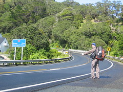
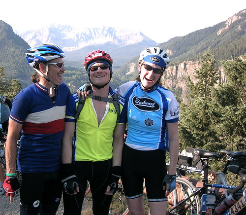
The guy on the left is Kyle. He was our third and final ride of the day, taking us from Whangarai all the way to Kaitaia. He was into fast cars, heavy metal, and partying. He said he was driving considerably slower than usual so we'd be comfortable. What a nice guy. I was especially thankful during the last 30 minutes or so, riding through the tight switchbacks of the Mangamuka.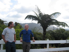
After staying at a really dumpy backpackers in Kaitaia, we paid to take a bus tour to Ninety Mile beach. The bus drives on the sand, up the beach for about 1.5 hours at low tide. Before it turned inland for the return trip, it dropped Kat and I on the beach at Te Paki stream. We planned to do a 2 day hike (the Cape Reinga Walkway) that goes up the beach and around the cape. Here I'm observing an Australasian Gannet - don't know if he was ill, or just in a mellow mood.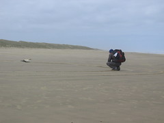
After hiking up Ninety Mile beach, we reached a staircase taking us up and over Scott Point. This is the view looking back down towards Ninety Mile Beach.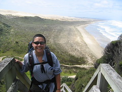
Another view on top of Scott Point, this time looking North towards Twilight beach.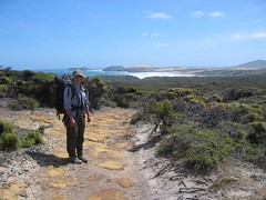
After hiking over Scott Point, then up the length of Twilight Beach, we made camp for the night in a small clearing. As you can probably tell, it was a little chillier than expected (we were hoping for warm sunny beach weather!) What you can't see in this photo, is just how windy it was (extremely windy).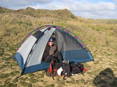
Twilight Beach, near sunset.
Under an outcropping of rock (kind of like a shallow cave) near our camp at the North end of Twilight beach, at low tide. It was totally inaccessible at high tide.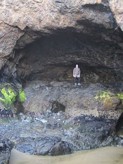
View from inside shallow cave at N end of Twilight beach. Swallows were nesting in here, and were quite unhappy that we were poking around, so we didn't stay long.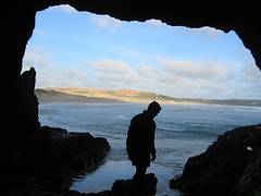
The following day had us hiking overland from Twilight Beach, over some huge sand dunes. Continuing upward, we reached a landscape that was almost Martian-like in it's barren-ness ... all sand and rock, no vegetation to be seen anywhere. Tons of broken seashells though - not sure how they got up that high, whether birds flew them up there, or they arrived by some other means.
***insert photo of martian landscape***
If it had been low tide, we could have slid down a big sand dune and walked on the beach around a point, but the tide was rising and we didn't know what lie around the point, so we took the safer option and hiked around the point overland, down to TeWerahi Beach. Lunched at a grassy spot overlooking the beach (a light lunch, since Kat underestimated the amount of food to bring, so we were rationing.) We met a lone backpacker hiking in the other direction as we started hiking up the beach - the only other backpacker we saw on the trip - he had come from Tapotupotu Bay, our destination for the night. Found the top half of a Portugese Man-o-War jellyfish, but didn't take a picture because I didn't figure out what is was until later.
At the N end of the beach we couldn't find the trail - we had either lost it, or it picked up somewhere around the point, which was quickly being overtaken by the rising tide. After scouting around and still not picking up the trail, we decided to make a break for it, timing the waves and working our way around the point. We waded through some calf-deep water and picked our way around the rocky point, thankful to find the trail on the other side. A steep uphill section, and some hiking along a ridge led us to Cape Reinga - one of the northernmost points of NZ, and the place were the Tasman Sea collides with the Pacific Ocean.
***insert photo from ridge***
***insert photo of Cape Reinga***
The guide book said there was a shop selling food up at the Cape, but alas - None! From the lighthouse, the trail headed down to the gorgeous secluded little Sandy Bay - if the weather had been warmer it would have been a tropical paradise! Onward to Tapotupotu Bay (with some steep climbing and descending along the way), where there were a handful of fishermen off the point, and a nice sandy beach. We camped there for the night, I did some tidepooling, spotting a few starfish, anemones, snails, limpets, crabs, fun stuff like that.
The following morning, we broke camp and were picked up by another tour bus for the return trip to Kaitaia. The only other people on the tour bus were an Australian couple (who we would briefly, randomly bump into on a bus in Auckand several days from now) and Julie, a friendly British woman who was touring the country in a friends vintage 1960's Rover Mini. We were both heading to Bay of Islands the following day, so she offered us a ride which we gladly accepted - and surprisingly it did quite nicely with 3 people and our gear!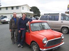
Kat and I spent the next 2 days in Paihia, a small town in the Bay of Islands, another gorgeous area. It has many sheltered bays and tons of little islands. We didn't do a ton of exploring, we mainly just chilled out a bit, did some laundry, and enjoyed a little downtime and the luxury of being in the same place for more than one night. We stayed at the Saltwater Lodge backpackers, which we highly recommend. It's a newer building, purpose built as a multistory backpackers. (The surest sign that it's a great place - one day, we hung our laundry outside, but forgot it in the rain - we later found our laundry neatly folded in the laundry room - some angel had taken it inside and folded it for us!)
The one thing we did in Bay of Islands was visit the Waitangi National Reserve, featuring the Treaty House. It was in this place in 1840 that the Treaty of Waitangi was signed between the native Maori people and the British crown, effectively granting the Maori full equality as British subjects, while granting the Crown governing authority. Apparently there is much disagreement surrounding interpretation of this treaty today, along veins similar to disagreements surrounding treaties signed in the americas with native americans. Given her background in law and Native American rights issues, Kat found the treaty grounds to be absolutely fascinating - and I found them interesting in my own right.
This photo is of a huge war canoe, made using mostly traditional methods in 1940 to memorialize the Centennial of the treaty signing. You can't tell from this photo, but the canoe was made from 3 huge hollowed out Kauri trees, and seated somewhere well upwards of 100 people.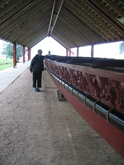
posted by equipoise at 2:48 PM
0 comments
![]()